Poland, 1935
The Dreams of a Doomed Society
This poster, my final project for my first university-level cartography class, was a product of hundreds of hours of work, and one of my longest-standing historical passions, Interwar Poland (1918-1939). I know that portfolios don't typically enjoin their viewers to read, but there is so much more to this map than meets the eye, and I am certain that I have not done justice to the sense of historical weight and sheer dread that informs this map. Interwar Poland was a post-apocalyptic society that, tragically, was also pre-apocalyptic. World War I was extremely hard on the Polish heartland, and the region collapsed into bloody anarchy at the end of the war. It's almost impossible to convey how chaotic Central and Eastern Europe was between 1918-1922. During this time, the new Polish state, emerged after 123 years of foreign occupation, fought nearly all its neighbors, including Czechoslovakia, Lithuania, Ukraine, Weimar Germany, and, famously, Soviet Russia.
Source: The Warsaw Institute, 2018.
It is also very important to remember that Poland was heavily multi-ethnic in the 1920s-30s. About 1 in 3 Polish citizens, even when using the heavily-biased 1931 Census, did not speak Polish at home. The remainder spoke Ukrainian, Belarusian, German, Lithuanian, or, notably Yiddish (as roughly 1/5 of the global Jewish population resided in Polish cities and shtetls). For a country founded on a bedrock of Polish Nationalism, this presented a source of chronic unrest.
Although torn by a culture war over Polishness, its once-democratic government overthrown by a military dictatorship, its economy stymied by a ruinous trade war with the vengeful and embittered Weimar Republic (and nearly gutted by the Great Depression), its eastern provinces experiencing separatism and ethnic turmoil, and its international reputation sullied by a history of opportunistic aggression, Poland had, against all odds, established itself as a regional power with real growth potential for the rest of the 20th century. My map poster is intended to reflect the cautious optimism some within the Polish government may have felt by the mid-1930s, from their perspective.
Everything in and about that map, however, is overshadowed by our present-day knowledge of what actually happened. It would be something of an understatement, bordering on criminal, to declare that World War II changed everything. It is almost impossible to overstate how much damage was done to the fabric of Polish society between 1939-1945. The country we have today is almost unrecognizable, compared to what came before.
In very brief summary, by 1939, Poland was completely painted into a corner, partly by its own actions.

In 1919, A small strip of land, inhabited mostly by Polish speakers, was seized by Czechoslovakia while Poland was busy fighting Ukraine. 19 years later, on the very day that Nazi troops marched into the Sudetenland (1), Poland opportunistically seized the disputed region (2). Source.
Poland's fate was sealed by the Molotov-Ribbentrop Pact of 1939, when the Soviet and Nazi governments mutually and secretly agreed to (among other regional aspirations) partition Poland between them. Adolf Hitler openly desired eastward German expansion, especially the reconquest of the areas formerly held by Germany before WWI. Stalin, who had been a senior commander during the Polish-Soviet War, also aspired to retake all the land that Russia had lost since 1918, especially the eastern regions of Poland.
One week after the Molotov-Ribbentrop Pact was signed, Germany invaded Poland. Two weeks after that, the Soviet Union invaded from the East. 19 days later, Poland was defeated, and split between Nazi Germany and the Soviet Union, as agreed. Both the German and Soviet governments inflicted ugly, brutal reprisals against ethnic Poles, intended to erase their presence from disputed regions.
The full story of Occupied Poland is effectively impossible to tell, and far beyond the scope of this project. Either way, Poland was devastated. According to a 2009 report by an affiliate of the Polish government, approximately 5.6-5.8 million Polish citizens were killed (divided roughly evenly between Ethnic Poles and Polish Jews).
Source: Institut national d'études démographiques, 2015. Poland's population fell from about 35 million to 22.7 million, between 1939-1945. It didn't recover its pre-war population until the late 1970s.
All this doesn't do justice to how the composition of Poland changed post-war. Nearly 90% of Polish Jews were murdered in the Holocaust, and most of the survivors did not stay. However, this does not explain why modern Poland is currently one of the most ethnically-homogeneous countries in Europe. In 2021, Ethnic Poles comprised about 98.6% of the population. This happened between 1944-1946, because Soviet-Occupied Europe was subjected to arguably the largest single, state-sanctioned mass deportation/ethnic cleansing operation in human history.
Stalin's government had been conducting mass ethnic cleansing (via forced population transfer/mass deportation) since before WWII, characterizing entire ethnic groups as potential spies, or as "Enemies of the People", starting with deporting nearly all Soviet Koreans (Korea, at the time, being ruled by Japan, Stalin viewed Koreans as potential spies for Japan.) to Kazakhstan and Uzbekistan in 1937. Poles were next. Stalin had no intention of ever surrendering the land he'd taken with Nazi support, and was willing to remove the entire Polish population to ensure this. Massacres and deportations of Polish civilians took place between 1939-1941, and resumed as soon as Soviet forces re-entered Poland in 1944. Upon the German invasion in 1941, Stalinist ethnic cleansing only accelerated. Between 1941-1948, within the borders of the Soviet Union, about 3.3 million people (including Poles, Germans, Romanians, Estonians, Latvians, Lithuanians, Norwegians, Finns, Crimean Tatars, and Chechens, all of whom were essentially considered enemy ethnicities) were forcibly deported to Siberia and Central Asia, with hundreds of thousands dying in transit. (Stalin's Russia, Chris Ward, 1999, p. 196; The Economic Transformation of the Soviet Union, 1913-1945, R.W. Davies, et al., 1994, p. 79)
Soviet-sponsored ethnic cleansing programs were not limited to its own borders. The most severe reprisals were directed at the formerly-widespread German diaspora of Central and Eastern Europe.
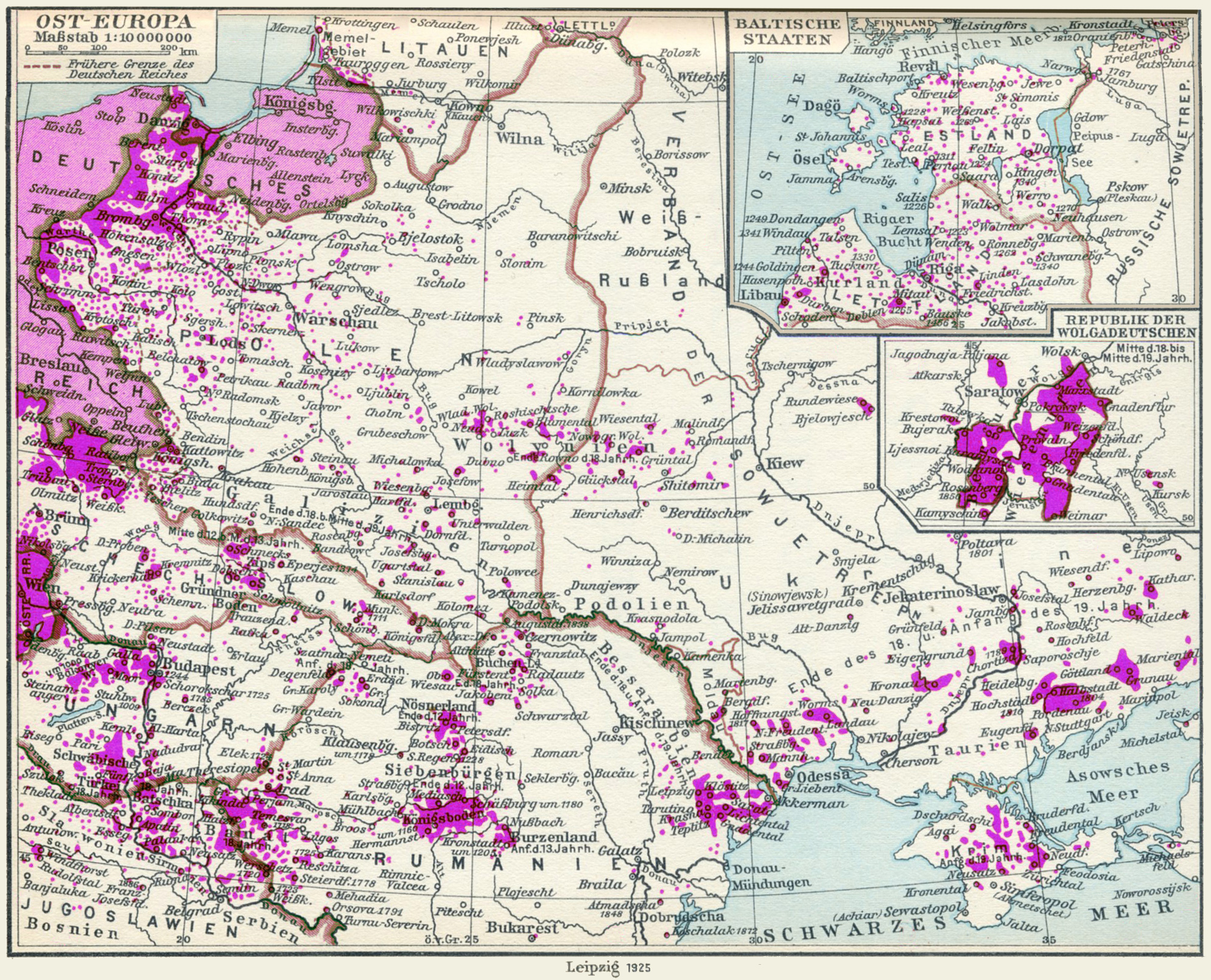
German-speaking populations across Central and Eastern Europe in 1910, mapped with 1925 national borders. Source: Historischer Schul-Atlas, 1927.
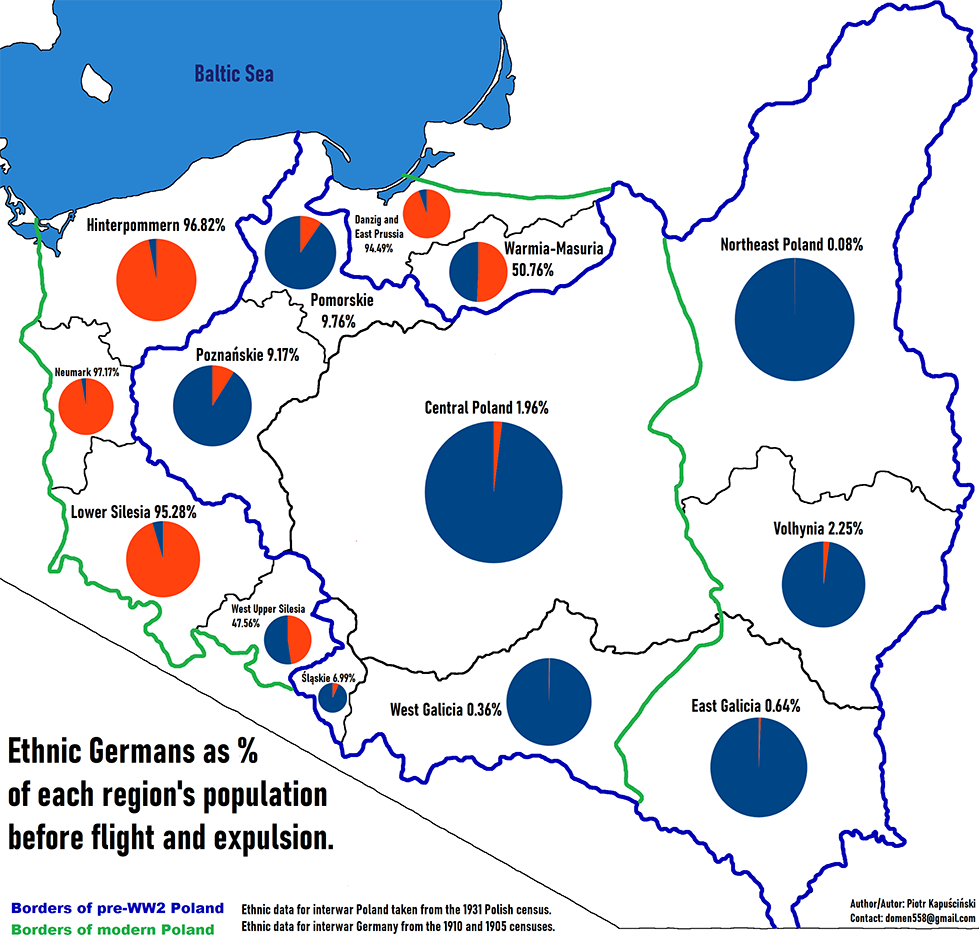
With the exception of Austria, visible on the far left of the above map, almost none of these areas contain significant German-speaking populations today. The flight and expulsion of Germans from eastern and central Europe saw the displacement of somewhere between 12 to 14.6 million people, and the deaths of anywhere between 500,000 to 2.5 million.
This finally takes us to the before-and-after of Polish borders, one of the most visible manifestations of post-war ethnic cleansing. It would be a gross misrepresentation to state that the Polish borders were merely shifted westward. Millions of people were driven from their homes and forcibly resettled to accomplish this. Despite historical claims, based on medieval Slavic-speaking populations and Polish rule of the region in the 11th and 12th centuries, most of the blue areas were majority-German, some of which had been so for nearly 700 years. These people either fled the Soviet advance from 1944-5, or were deported to East Germany at gunpoint between 1945-6. Similar mass flights and ethnic cleansing took place in other Soviet vassals, such as Czechoslovakia, Hungary, and Yugoslavia. Stalin was determined to punish Germany, and to ensure it could never threaten Russia again. However, part of this strategy was to create a viable Polish puppet state that could serve as a buffer between Germany and the Soviet Union. This was complicated by Stalin's refusal to return any of the land he had taken in 1939. At the Potsdam Conference of 1945, Stalin and the other Allied leaders agreed to proceed with their plans to remove the German populations in question, and negotiated a sort of 'compromise' for the fate of Poland.
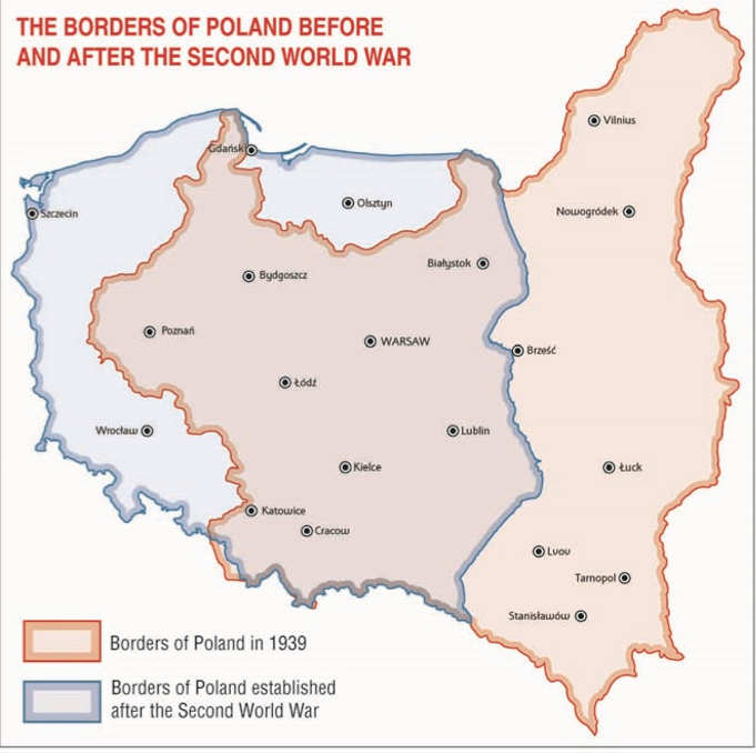
Source: Instytut Pamięci Narodowej (Institute of National Remembrance), 2022.
Poland's new eastern border would largely reflect areas of overwhelming Polish majority, with the areas east of it remaining a part of the Soviet Union. All German territories east of the Oder and the Lusatian Neisse Rivers would be annexed by Poland (except for what is now Kaliningrad Oblast, annexed to the Russian Soviet Socialist Republic, to ensure that Russia acquired a warm-water port in the Baltic). All remaining Germans would be removed by force.
About 7 million German-speakers were forced out of the regions specifically annexed to Poland and the Soviet Union. Many of these areas were essentially deserted after the mass deportation of their German residents. These areas were resettled by, among others, many of the 1.24 million Poles deported from the areas annexed by the Soviet Union. The massive influx of mixed, heterogeneous populations into the so-called "Recovered Territories" of modern Poland was so sudden and pronounced that it is reflected in modern dialects of the language.
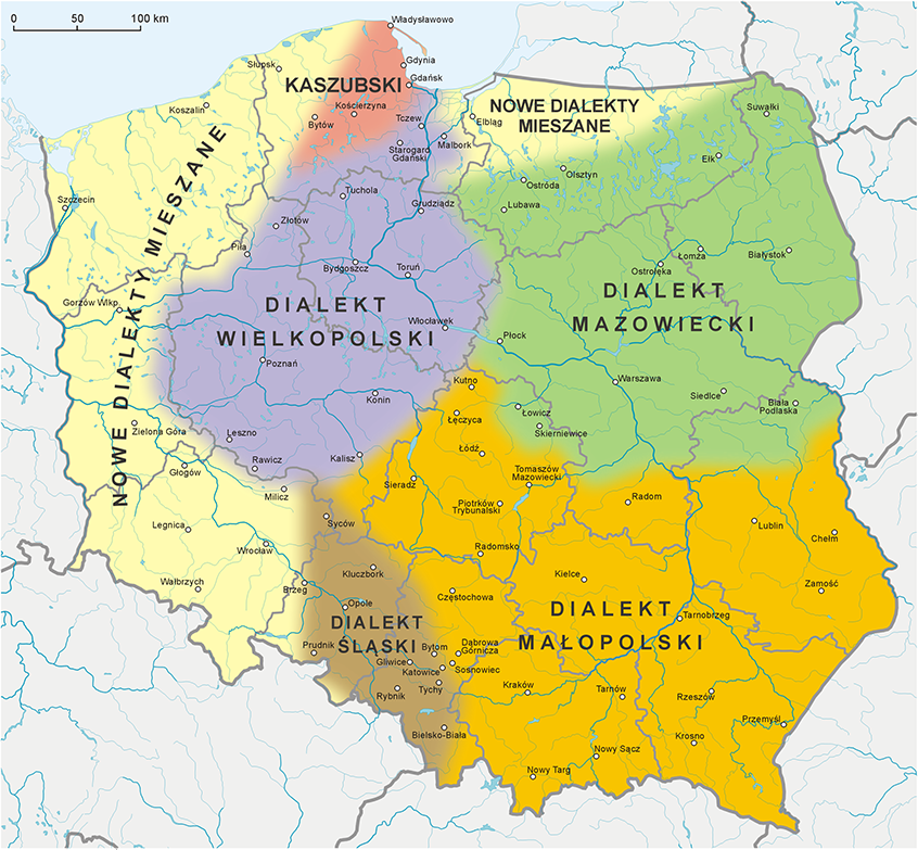
Source. The areas colored pale yellow/beige, labeled "Nowe dialekty mieszane" (New Mixed Dialects) are the areas where Polish resettlement of essentially-deserted areas caused pronounced dialect levelling, and the inhabitants of these places speak a language that is almost indistinguishable from modern literary Standard Polish, as taught in schools. The modern Polish identity of these regions was essentially built from the ground up in the second half of the 20th century.
With all that (rather dizzying) amount of historical context out of the way, I hope that the original poster can adequately convey the complicated and difficult emotions that I intended. Polish society in 2025, not unlike 1935, is post-apocalyptic. The world captured in my map, and the aspirations of the people involved, was destroyed. What we have now, is what the survivors were able to build. It's food for thought.
Credits:
Created via ArcGIS Pro & Adobe Illustrator
Sources:
Polish Census Data, 1931; Polish Administrative Divisions, 1935: Paul Thomas Dziemela, GISP (Data updated in 2014, accessed 2024) Census-Taking in the Age of Polish Nationalism (1999); Administrative Districts of Interwar Poland (1999).
Polish Populated Places, City Names, & Population Sizes: Prof. dr hab. Andrzej Gawryszewski, instytut geografii i Przestrzennego zagospodarowania im. stanisława leszczyckiego Pan; Warsaw Ludność Polski w XX wieku [The Population of Poland in the 20th Century.], pp. 552-587 (2005).
Interwar Polish Economics & Politics: Zofia Cichocka-Petrażycka, Państwowe Wydawnictwo Książek Szkolnych we Lwowie; Lwów (Lviv). Geografia Gospodarcza Polski Współczesnej [Economic Geography of Contemporary Poland] (1938).
Polish Census Data, 1931: Główny Urząd Statystyczny [Central Statistical Bureau], Warsaw. Drugi powszechny spis ludności z dn. 9.XII.1931 r. [Second General Population Census of December 9, 1931] (1938).
Elevation Data for Hillshade Construction: Shuttle Radar Topography Mission (SRTM) (2000, Accessed 2024) SRTM GL1 Global 30m DEM.
Coat of Arms of Poland (1928-1939): Osipov Georgiy (Uploaded 22. Jul 2009, Accessed 2024).
.svg)
Polish Railway Networks, Borders, Administrative Divisions, Place Names, & Population Sizes: Wojskowy Instytut Geograficzny [Military Geographic Institute], Mapa rzeczypospolitej polskiej (1934); Mapa schematyczna polski z granicami dowództwo okręgów i korpusowych i powiatowe komendy uzupełnień (1935); Mapa administracyjna Rzeczpospolitej Polskiej (1937), Warsaw.
Railroad, Graticule, & Water Vector Data: Natural Earth Project, Vector Data, (Accessed 2024).